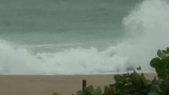
Typhoon Wipha is currently battering Hong Kong and Macau, bringing with it significant rainfall and winds comparable to those of a Category 2 Atlantic hurricane. As the storm approached, the Hong Kong Observatory reported sustained winds of approximately 106 miles per hour, accompanied by heavy showers and rising sea swells. The storm is forecast to escalate in intensity as it makes its way west toward Macau, ultimately destined for the mainland cities of Shenzhen and Zhanjiang in Guangdong Province later today.
In response to the approaching cyclone, Hong Kong issued a No. 10 hurricane signal—its highest warning level—marking the first such issuance since 2023. Similarly, Macau has raised an equivalent storm alert. Authorities have urged residents to remain indoors and take precautions against potential flying debris.
At Hong Kong International Airport, the chaos of the typhoon resulted in the rescheduling of over 400 flights, while nearly 200 flights were canceled at Macau International Airport. Southern Chinese cities have begun closing workplaces and ports, suspending train services and canceling additional flights.
In the city of Zhuhai, which is also in the path of Wipha, officials have closed down construction sites, parks, ferries, piers, and outdoor recreational areas. Schools and various workplaces have also shut down in Zhanjiang in anticipation of the storm.
After making landfall, Typhoon Wipha is predicted to traverse southern China before it moves offshore again, potentially impacting Vietnam. This story is still unfolding, and more updates are expected as the situation develops.