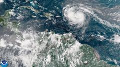
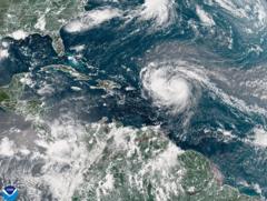
The powerful storm is forecasted to bring heavy rain and rough seas next week, while avoiding direct landfall on the U.S. mainland.
**Hurricane Erin Escalates to Category Five, Threatening Atlantic Areas**

**Hurricane Erin Escalates to Category Five, Threatening Atlantic Areas**
Hurricane Erin has rapidly intensified, posing a significant threat as it nears the Caribbean with winds of up to 160 mph.
Hurricane Erin has dramatically intensified to a category five storm, now boasting maximum sustained winds of 160 mph (260 km/h). According to the National Hurricane Center Director Mike Brennan, the storm "explosively deepened and intensified" overnight, escalating from its previous tropical storm classification on Friday.
As it progresses, Erin is expected to move north of the Leeward Islands, Virgin Islands, and Puerto Rico this weekend, potentially causing up to 6 inches (15 cm) of rain that may lead to flash flooding and mudslides. Despite its severity, current forecasts do not anticipate Erin making landfall on the U.S. mainland.
Meteorologists characterize Erin's rapid intensification as a period where a hurricane strengthens by at least 34 mph in a 24-hour timeframe. Notably, Erin's wind speeds jumped from 100 mph early Saturday morning to the current 160 mph, a significant leap. Looking ahead, the hurricane is forecasted to continue moving northward, passing east of the Bahamas and heading towards the Outer Banks of North Carolina in the following week.
Brennan sounded the alarm about the life-threatening surf and rip currents likely to batter the entire east coast of the United States next week, specifying that Florida and the mid-Atlantic states should prepare for the most perilous surf conditions. Bermuda may also experience dangerous surf and heavy rainfall.
In response to the threat, the U.S. Coast Guard has enacted restrictions for vessels at ports on St. Thomas and St. John in the U.S. Virgin Islands, in addition to six municipalities in Puerto Rico, including San Juan.
Moreover, the National Oceanic and Atmospheric Administration (NOAA) has indicated an "above normal" hurricane season in the Atlantic for this year, predicting an increase in the number of tropical storms reaching category four and five levels, an effect linked to global warming.


