Expect heavy rains and evacuations as the hurricane approaches the eastern United States.
Hurricane Erin Intensifies, Threatening Life-Saving Waves to US East Coast

Hurricane Erin Intensifies, Threatening Life-Saving Waves to US East Coast
Hurricane Erin strengthens to Category 4, sparking warnings for dangerous surf and rip currents.
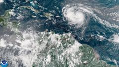
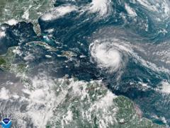
Hurricane Erin has rapidly escalated to a Category 4 storm, posing significant risks of life-threatening surf and rip currents along the eastern coast of the United States. The storm has begun to impact the south-eastern Bahamas and the Turks and Caicos Islands, where a tropical storm warning is currently active. Although Erin is not anticipated to make direct landfall on these islands, heavy rainfall of up to six inches (15.2 cm) is projected.
Classified as the inaugural hurricane of the 2025 Atlantic season, Erin underwent explosive intensification over the weekend, momentarily reaching Category 5 status before slightly diminishing in strength. In Puerto Rico, the storm's powerful winds have left over 150,000 residents without electricity due to damaged power lines. Fortunately, local energy company Luma reported that emergency repairs have restored power to 95% of its customers by Sunday evening local time.
The hurricane's outer rain bands are already affecting the Bahamas, prompting the US National Hurricane Center (NHC) to advise residents to prepare for potential impacts. Aarone Sargent, managing director of the country’s Disaster Risk Management Authority, emphasized the unpredictable nature of storms, urging Bahamians to familiarize themselves with nearby shelters.
The NHC has forecasted that Erin's core will move east of the south-eastern Bahamas in the coming days, progressing toward Bermuda and the eastern US coast. Forecasts also indicate that Erin will maintain its status as “a large and dangerous hurricane” during its approach. Meanwhile, the Outer Banks of North Carolina are preparing for severe surf and winds, leading authorities to implement a mandatory evacuation of Hatteras Island, as they caution that the primary highway linking Hatteras to other islands may become impassable. Rip tide warnings have also been issued for the entire US East Coast.


