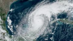
The Department of Defense has announced a temporary extension for crucial satellite data that supports hurricane forecasts, responding to concerns from scientists. The extension is essential but only lasts until July 31, shortly before the peak of hurricane season.
Critical Satellite Data for Hurricane Forecasts Extended for One Month Amid Concerns

Critical Satellite Data for Hurricane Forecasts Extended for One Month Amid Concerns
U.S. officials will continue to provide key satellite data for hurricane monitoring until July 31, after previously planning to cut it off on June 30.
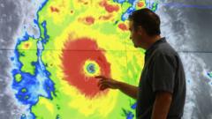
The Department of Defense (DoD) has made a pivotal decision to extend access to vital satellite data, crucial for hurricane forecasting, until July 31. Initially slated to be cut off on June 30, this data plays a key role in monitoring hurricane movements and structures. The National Oceanic and Atmospheric Administration (NOAA) had initially announced that data from three satellites, jointly managed by NOAA and the DoD, would no longer be available to researchers and forecasters, citing “recent service changes” without elaborating.
However, on a recent update, NOAA attributed the decision to continue providing data to a “significant cybersecurity risk” concerning the information's safety. The extension was made possible following a request from a NASA scientist, highlighting the seriousness of the implications for weather forecasting. Meteorologists expressed profound concern when they first learned about the planned termination of this data, stressing that its loss would undermine the quality of hurricane forecasts and pose increased risks to lives and property.
Experts like Michael Lowry, who have worked with the National Hurricane Center, emphasized the critical nature of this extension, although it falls short of covering the peak months of the hurricane season, which stretch into August, September, and October. The data’s relevance extends beyond just hurricane tracking; it is also indispensable for climate research, particularly studies monitoring changes in polar sea ice since the 1970s.
Without this important data stream, researchers would find it immensely challenging to observe crucial climatic changes instrumental to understanding global warming. Sharon Stammerjohn, a senior research associate at the University of Colorado Boulder, noted the necessity of tracking seasonal sea ice dynamics in Earth’s polar regions, stating that a lack of consistent imagery would severely hinder climate monitoring efforts.
While alternatives from agencies like the European Space Agency and Japan's Aerospace Exploration Agency may exist, challenges with integrating their data arise due to variations in calibration and resolution. Thus, while the extension offers temporary relief for hurricane forecasting, much work remains to secure reliable data streams for broader climate science studies.