Recent catastrophic flooding in Texas underscores the urgent need for updated climate adaptation strategies.
Extreme Rain Events Surge Amid Global Warming Crisis

Extreme Rain Events Surge Amid Global Warming Crisis
Increasingly severe deluges linked to climate change threaten infrastructure and safety in flood-prone areas.
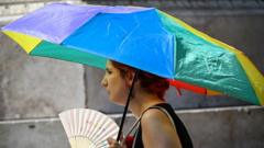
As global temperatures continue to rise, the frequency and intensity of extreme rain events are escalating, as evidenced by the devastating flooding in Texas. This poignant situation exemplifies how human-induced climate change is significantly influencing weather patterns worldwide.
The increased warmth of the atmosphere allows it to hold more moisture, leading storms to unleash more substantial rainfall. In Texas, an area historically familiar with varied climate extremes—ranging from sweltering heat to frigid cold—recent storms reached unprecedented levels of severity. These conditions shifted ordinary rainfalls into torrential downpours, overwhelming infrastructure and existing emergency warning systems.
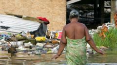
Particularly in the Hill Country—dubbed "flash flood alley"—the combination of humid air from the Gulf of Mexico and the Pacific Ocean creates a volatile mix. This unstable combination can swiftly result in severe storm activity when colliding with cooler air from the Great Plains. The local hilly landscape exacerbates the situation, swiftly channeling rainwater into river valleys and transforming gentle streams into monstrous torrents.
The latest storm in Texas delivered an alarming amount of rain within a matter of hours. Meteorological assessments reveal that the rain's extremes had a less than one-in-a-thousand chance of occurring in the region during any given year. This rapid deluge led to the alarming rise of the Guadalupe River, which surged from three feet to an unprecedented 34 feet in just 90 minutes. In tandem, water flow surged dramatically from 95 cubic feet per second to an astonishing 166,000 cubic feet per second, showcasing the sheer volume of flooding faced by communities in the area.
This trend of increasingly severe weather events calls for urgent measures in upgrading flood management systems and enhancing community preparedness to prevent future catastrophes related to climate change.
The increased warmth of the atmosphere allows it to hold more moisture, leading storms to unleash more substantial rainfall. In Texas, an area historically familiar with varied climate extremes—ranging from sweltering heat to frigid cold—recent storms reached unprecedented levels of severity. These conditions shifted ordinary rainfalls into torrential downpours, overwhelming infrastructure and existing emergency warning systems.
Particularly in the Hill Country—dubbed "flash flood alley"—the combination of humid air from the Gulf of Mexico and the Pacific Ocean creates a volatile mix. This unstable combination can swiftly result in severe storm activity when colliding with cooler air from the Great Plains. The local hilly landscape exacerbates the situation, swiftly channeling rainwater into river valleys and transforming gentle streams into monstrous torrents.
The latest storm in Texas delivered an alarming amount of rain within a matter of hours. Meteorological assessments reveal that the rain's extremes had a less than one-in-a-thousand chance of occurring in the region during any given year. This rapid deluge led to the alarming rise of the Guadalupe River, which surged from three feet to an unprecedented 34 feet in just 90 minutes. In tandem, water flow surged dramatically from 95 cubic feet per second to an astonishing 166,000 cubic feet per second, showcasing the sheer volume of flooding faced by communities in the area.
This trend of increasingly severe weather events calls for urgent measures in upgrading flood management systems and enhancing community preparedness to prevent future catastrophes related to climate change.